|
| wnc business & community directory |
|
This is an archived page that may contain outdated or incorrect information. Please visit www.Asheville.com for the latest news, events, and more.
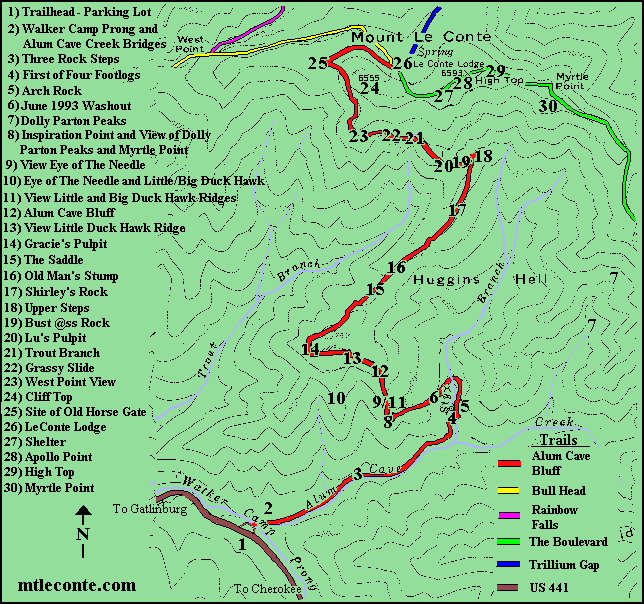 Many of the landmarks that are mentioned in the hiking logs are Mt. Leconte designations and do not appear on any map or in any official document. The trail map above is offered by Mt. Leconte to assist the hiker in finding these locations. The trailhead is 3880' above sea level. Once leaving the parking lot the trail crosses Walker Camp Prong and Alum Cave Creek via bridges. The trail continues along Alum Cave Creek. My half mile marker is a crooked tree that bends over the trail just before three rock steps. Three fourth miles up the trail is an open area with a large maple tree in middle of the trail. The trail takes a sudden turn to the left and gets steeper just beyond this location. It follows Styx Branch instead of Alum Creek. The foot logs are obvious and cross Styx Branch. Numbers of the footlogs depend upon my direction of travel. The first footlog is one mile above the trailhead. Arch Rock is an obvious landmark. The top is about 4400' elevation and 1.3 miles from the trailhead. Arch Rock is between the third and fourth footlog. The big washout of June 28th 1993 comes next. Inspiration Point two miles from the trailhead and follows the Washout. It is about 4700' elevation and is an official designation. It is comprised of an out cropping of rocks that provide a view of Little Duck Hawk Ridge to the front and the Dolly Parton Peaks looking down the trail. The Dolly Parton Peaks have also been called "Boobs Ridge." You can also see Myrtle Point from this location. It is above and to the left of Dolly Parton Peaks. After taking a sharp right turn, the trail scales rocks and heads for the Alum Cave Bluff. Half way between Inspiration Point and Alum Cave Bluff the Eye of The Needle can be seen across the crevasse on Little Duck Hawk Ridge. Two holes in this ridge can be seen from Inspiration Point and from the lower parking lot. Big Duck Hawk Ridge is behind Little Duck Hawk Ridge. Alum Cave Bluff is 2.2 miles above the trailhead and an elevation of about 4950'. It is no cave at all, but a concaved cliff about eighty feet high and five hundred feet long. In winter icicles as large as a human body hang from the bluff. The hiker is warned that these icicles sometimes crashes onto the trail. Inside the bluff is a good location to rest and to get out of the rain. The trail passes above the tops of Little Duck Hawk and Big Duck Hawk Ridges. There are manways across these ridges but they are closed because of the nesting peregrine falcons. The half way point is now called Gracie's Pulpit. It is 2.5 miles above the trailhead and an elevation of about 5200'. It's previous name was the Devil's Pulpit, because it overlooks Hudgens Hell. Hudgens Hell is drained by Styx Branch. Both are official names. People renamed the half way point Gracie's Pulpit in honor of the late Gracie McNicol. Great views of the four peaks of Mt. LeConte that soar above 6200 feet are clearly visible from this location when the weather is clear. These peaks are named West Point, Cliff Top, High Top, and Myrtle Point. At this location the trail levels out and actually drops about 80 to 100 feet to the saddles, there are three, are between Peregrine Peak and Mt. LeConte. Some people think that they have missed the trail because of this down hill section. The trail to the saddles is nice going up the mountain but tough on the return trip. After the saddles there are lots of rocks and roots as the trail starts to climb again. At one steep climb, there are two dead tree stumps on the right. Before the trail crew worked on this area, older fellows, like myself and the late Paul Dinwiddie, used the stumps to pull ourselves up the steep, rocky sections. As a matter of fact, I still make use of the Old Man's Stump today. A short distance beyond the stumps, there is an open space with a tree trunk about eight feet above the trail and to the right. This is my three-mile point. About half way to the upper steps, there is a large rock outcropping that must be climbed. I call this Shirley's Rock for Shirley Henry from Maryville. The trail crew chiseled steps in the rock to make it easier to climb and descend. Next come the upper steps. They are at a switch back and are about 5700' elevation. A few hundred yards above steps, are the Bust @ss Rocks. These are sharp rocks and a narrow ledge. Many people fall here. Above that location the trail takes a sharp turn to the right. A tree with lots of roots to the left of the trail, provides a spot for hikers to sit and rest. This spot is Lu's Pulpit, named for the late Ernest Luellen who suffered a fatal heart attack while hiking this trail. Before reaching Grassy Slide a stream crosses the trail. It is officially called Trout Branch. Others call it Mossy Springs, because of all of the moss. I call it Little Niagara Falls, because of its horse shoe shape and quantity of water that gushes over the trail during rainstorms. Grassy Slide is four miles above the trailhead and a mile from the lodge. It is about 6,000' above sea level and it is a large expanse of grass with good views of Newfound Gap, Gracie's Pulpit, Clingmans Dome and the many layers of mountains stretching to North Carolina. There is now a second slide just beyond this location. Continuing up the trail, there was once a large root that protruded from a tree that was handy to step on to climb the rocks at this location. Others named it the John Holmes Memorial Root. It has now broken off and is no longer a specific location. Above this once proud spot the most Westerly of the four peaks, soaring above 6200 feet comes into view. That peak is called West Point. At this point the hiker is almost to its elevation and that is why I call it West Point View. The next fourth of a mile the trail is immediately beneath Cliff Top. There was once a barrier across the trail in the saddle between West Point and Cliff Top. This location is about 0.3 miles from the lodge and is called the site of the Old Horse Gate. It is about 6350' elevation. The gate is gone today, but in preceding years it served to prevent horses and riders descending the mountain from riding onto dangerous sections of the Alum Cave Bluff Trail where they might not be able turn back. Just before reaching the lodge the trail junctions with the Rainbow Falls/Bull Head Trails and the Boulevard Trail. This is the end of the Alum Cave Bluff Trail. The lodge represents the end of may hikes, but the two remaining peaks are further down the trail. The trail passes a man made shelter that sleeps 12 people. The shelter must be reserved through the park service for a single nights use. Continuing up the trail the hiker reaches a clear rock face called Apollo Point. This location received its name from the days when viewers could see the Apollo Saturn V boosters climbing into orbit. A few hundred yards further is High Top. High Top, elevation 6593, is the tallest of the four peaks. In fact the height of High Top fluctuates as the pile of stones atop it grows and shrinks. Views from this peak are obscured by trees. The final peak, Myrtle Point is still a fourth of mile away. The sign directing hikers to this peak is currently missing. The trail should be apparent as it crosses the ridge between the peaks. This trail is fairly flat and the hiker that looses much altitude has probably taken a wrong turn. The five trails to the Lodge and their ratings are as follows: 1) Alum Cave Bluff Trail: 5.5 Miles. The shortest, fastest, steepest and the most scenic. 2700' elevation Change. Unquestionably my favorite trail. 2) Bull Head Trail: 7.5 Miles gradual, long. A nice trail for descending 4000' elevation change. For a round trip hike go up Rainbow Falls trail and hike down the Bull Head Trail. They both have the same parking lot at their trailheads. 3) Rainbow Falls: 6.5 Miles, rocky, steep, 4000' elevation change. Too many loose rocks for a safe descent. 4) Trillium Gap Trail: 6.5 Miles, nice, Roaring Forks Road is very steep to the trailhead and back down to Gatlinburg. 3500' elevation change. Beautiful walk under Grotto falls. 5) The Boulevard Trail: 8.8 Miles. Many hikers think that the 1700 ' elevation change and the long distance means a gradual climb. Unfortunately the hike up has lots of ups and downs. (Trail map and descriptions provided by Ed Wright who produces www.mtleconte.com.)all contents copyright © 1999, asheville.com. contact: [email protected] or 828.253.2880 For listing and advertising information...
|
